
Weather Whiplash: Why Extreme Heat and Cold Hit Together
It's not weird weather. It's a changed atmosphere with new rules. Here's the framework for understanding why hot and cold extremes now hit simultaneously.
Weather Whiplash: Why Extreme Hot and Cold Hit the Same Country at Once
In the winter of 1816, a volcanic eruption in Indonesia dropped global temperatures enough to kill crops across the Northern Hemisphere. New England farmers called it "Eighteen Hundred and Froze to Death." What made that year catastrophic wasn't just the cold. It was the instability: frosts in June, heat waves in August, snowstorms in September. The atmosphere had lost its predictable rhythm, and nothing that depended on that rhythm survived intact.
Two centuries later, the mechanism is different but the instability is the same.
The Whiplash Illusion: Why We Keep Calling This "Weird Weather"
When Washington, D.C., records 86°F on a Wednesday and snow on Thursday, the instinctive response is to call it weird. Anomalous. A fluke. That framing is wrong, and it's costing people the ability to prepare for what's coming.
Call this the Seasonal Stability Bias: the deep assumption that weather within a given month should behave within a predictable range, because that's what living memory encodes. For most of the 20th century, that assumption was mostly accurate. March felt like March. July felt like July. The atmosphere delivered seasons with enough consistency that the word "unseasonable" meant something unusual.
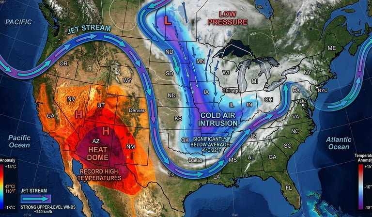
That assumption is now a liability. Researchers studying jet stream behavior, including a body of work published in journals including Nature Climate Change and Geophysical Research Letters, have documented that the polar jet stream, the high-altitude river of wind that separates Arctic and temperate air masses, has become more meandering and more prone to locking into extreme positions. The mechanism is well-established: as Arctic sea ice shrinks, the temperature differential between Arctic and mid-latitude air decreases, which reduces the pressure gradient that keeps the jet stream tight and fast. A slower, wavier jet stream produces exactly what we're seeing: extreme heat and extreme cold existing in close geographic proximity, sometimes within the same week.
This isn't weird weather. It's a changed atmosphere behaving according to its new rules.
Reading the Forecast Map Like a Climate Scientist
The three-step framework for understanding weather whiplash separates what's happening right now from what it means over time.
Step 1: Stop asking whether a single event is caused by climate change. That's the wrong question, and it produces the wrong answer every time. Individual weather events aren't caused by climate change the way a car crash is caused by a blowout. The more accurate frame is probability: climate change loads the dice toward certain outcomes, making extreme heat events more frequent, more intense, and earlier in the season. When Phoenix hits 107°F in March after 137 years of never breaking 100 before March 26, that's not a random outlier. It's a probability distribution that has shifted.
Step 2: Track the jet stream, not just the temperature. The National Weather Service's Weather Prediction Center publishes daily jet stream maps at weather.gov. A jet stream that dips far south over the central US pulls Arctic air down with it. A ridge that amplifies over the Southwest traps heat underneath. When both patterns exist simultaneously, as they do this week, the map produces simultaneous extremes that appear contradictory but are in fact expressions of the same atmospheric configuration. Former NOAA chief scientist Ryan Maue described it plainly: the jet stream peak acts as a mountain, pushing Pacific storms up to grab cold air and drag it south while the Southwest bakes underneath a stationary high-pressure dome.
Step 3: Update your personal risk model seasonally, not annually. Most people carry a mental model of weather risk that's calibrated to historical norms. March used to mean a low probability of extreme heat in Phoenix. That probability has moved. The practical update is to treat early-season heat with the same caution as peak-summer heat, to check 14-day forecasts rather than weekly ones, and to recognize that the gap between an uncomfortable week and a dangerous one is now smaller than historical experience suggests.
The Optimism Bias That Keeps People Unprepared
The psychological force keeping most people from updating their weather risk model is Optimism Bias: the well-documented tendency, described by researcher Tali Sharot at University College London in a 2011 paper in Nature Neuroscience, to believe that bad outcomes are more likely to happen to others than to ourselves. Applied to extreme weather, it shows up as the persistent sense that the dangerous event will track slightly north, or arrive slightly weaker, or affect the next town rather than this one.
Optimism Bias isn't irrational. In stable conditions, slightly overestimating your safety margin costs almost nothing. In a changed atmosphere where the historical baseline no longer predicts current conditions, that margin erodes. The eight people killed by tornadoes in Oklahoma, Michigan, and Indiana in the week before this forecast didn't expect it to be them. The residents of Phoenix who aren't heat-acclimatized in March won't feel the danger until they're already in it.
The corrective isn't pessimism. It's calibration: using current data rather than historical intuition to assess what's actually likely, and building preparation habits that don't depend on the old normal returning.
The atmosphere that produced a stable 20th century climate was not permanent. The one replacing it runs hotter, more erratically, and with extremes that arrive earlier in the year than anyone alive has experienced before. The forecast for this week is a data point in that pattern, not an exception to it.
If your risk model still treats extreme early-season weather as a surprise, it's time to update it before the next forecast arrives.
This is exactly the kind of analysis we publish every week for SevScience subscribers, before it reaches mainstream news cycles. Subscribe free. Stay a step ahead.
